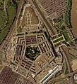
Tiedosto:Pentagon satellite image.jpg

Tämän esikatselun koko: 632 × 600 kuvapistettä. Muut resoluutiot: 253 × 240 kuvapistettä | 506 × 480 kuvapistettä | 809 × 768 kuvapistettä | 1 079 × 1 024 kuvapistettä | 2 261 × 2 146 kuvapistettä.
Alkuperäinen tiedosto (2 261 × 2 146 kuvapistettä, 4,02 MiB, MIME-tyyppi: image/jpeg)
Tiedoston historia
Päiväystä napsauttamalla näet, millainen tiedosto oli kyseisellä hetkellä.
| Päiväys | Pienoiskuva | Koko | Käyttäjä | Kommentti | |
|---|---|---|---|---|---|
| nykyinen | 18. lokakuuta 2022 kello 17.08 |  | 2 261 × 2 146 (4,02 MiB) | Cryptic-waveform | File:Pentagon-USGS-highres.jpg cropped 29 % horizontally, 39 % vertically using CropTool with precise mode. |
| 13. kesäkuuta 2005 kello 17.40 |  | 565 × 536 (108 KiB) | Neutrality | U.S. Geological Survey satellite image of the Pentagon, taken April 26, 2002. The reconstruction of the section damaged in the September 11 terrorist attacks is visible on the building's west (l |
Tiedoston käyttö
Seuraava sivu käyttää tätä tiedostoa:
Tiedoston järjestelmänlaajuinen käyttö
Seuraavat muut wikit käyttävät tätä tiedostoa:
- Käyttö kohteessa ar.wikipedia.org
- Käyttö kohteessa bh.wikipedia.org
- Käyttö kohteessa bn.wikibooks.org
- Käyttö kohteessa da.wikipedia.org
- Käyttö kohteessa de.wikipedia.org
- Käyttö kohteessa en.wikipedia.org
- Käyttö kohteessa en.wikibooks.org
- Käyttö kohteessa en.wikinews.org
- Käyttö kohteessa en.wikiquote.org
- Käyttö kohteessa eo.wikipedia.org
- Käyttö kohteessa fr.wikipedia.org
- Käyttö kohteessa fr.wiktionary.org
- Käyttö kohteessa he.wikipedia.org
- Käyttö kohteessa hy.wikibooks.org
- Käyttö kohteessa id.wikibooks.org
- Käyttö kohteessa it.wikipedia.org
- Käyttö kohteessa it.wikiquote.org
- Käyttö kohteessa min.wikipedia.org
- Käyttö kohteessa ms.wikipedia.org
- Käyttö kohteessa nn.wikipedia.org
- Käyttö kohteessa ru.wikinews.org
- Käyttö kohteessa scn.wikipedia.org
- Käyttö kohteessa tl.wikiquote.org
- Käyttö kohteessa uz.wikipedia.org
- Käyttö kohteessa vi.wikipedia.org
- Käyttö kohteessa vi.wikibooks.org
- Käyttö kohteessa zh.wikipedia.org
- Käyttö kohteessa zh.wikinews.org


